
Technical information
ThermoGIS displays only geological layers with realistic potential for geothermal energy and high‑temperature storage (HTO). The natural properties of these geological layers, also known as aquifers, are sufficiently favourable to enable the extraction of adequate volumes of water.
The mapping of geological layers partly depends on data availability and data density. As a result, certain layers may not be included in ThermoGIS because insufficient information is available about them. The maps in ThermoGIS are mapped and modelled at a regional scale. Consequently, the values shown may differ from reality at a local level.
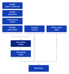
The flow diagram shows the ThermoGIS workflow. All elements of the diagram can be clicked for more information.
Scientific basis
The ThermoGIS workflow has also been described in the following papers:
- ThermoGIS update: a renewed view on geothermal potential in the Netherlands(European Geothermal Congress 2019)
- ThermoGIS: from a Static to a Dynamic Approach for National Geothermal Resource Information and Development (World Geothermal Congress 2020+1)